Finding
a
New
Adventure
(Why we chose to take on a crazy road trip like this and how geocaching led us to it.)
Driving along a red dirt road, one of the boys yells out that we are getting closer. Ron pulls the car over, and all four of us head into the woods. The bush here was incredibly thick. Spruce trees surrounded each of us within moments of entering the wooded area, and before we knew it, no one could see anything except the branches of whatever tree happened to smack you in your face.
“I’m at Ground Zero, but I got nothing” from one voice.
“Mine’s just spinning. Any luck?” another asks.
Known as the “drunken bee dance,” the four of us had engaged in a relatively common practice of walking circles around the same area looking for the same thing. Examining every branch, and every limb of every tree we spotted, no one was coming up with the find. The hint itself seemed incredibly simple, and the name of the geocache seemingly gave it away. We suspected it was small as much of what we had found earlier could easily fit in your hand. But just as I was about to call it and tell the boys to move on to the next one, I hear Paul’s voice.
“I’ve got it!” Paul squawked with a bit of joy in his voice.
We all had a small sigh of relief and started to head back towards the car.
“You guys have got to see this,” he said. The name of what we were looking for was “Another micro in the woods” (GC1GVCM) and given that the term “micro” depicts the container to be small enough to fit in your hand, I cast my doubts on whether or not it made much sense to see yet another film canister in a tree. But we all knew that Paul wouldn’t have grabbed our attention for something so simple. The rest of us made our way through the trees, following his voice until eventually, we came upon the “micro” he had found in the woods.
Sitting along the branch of one of the smaller spruce trees was a microwave oven. An actual microwave oven, in the middle of the woods, hanging from a tree was the “micro” we had been looking for. Inside the oven was a tobacco canister that had the log sheet, and all four of us started laughing. Someone snapped a picture of Ken beside the microwave before we all signed the log, put the container back in the oven, and kept on moving. The misdirection of the name combined with the hilarious idea of a microwave in a tree have made that geocache stand out as one of my all-time favorites in the 12 years that I have been geocaching.
For the next four years, all four of us would return to PEI on that same weekend to go geocaching. Through the course of Friday evening, all of Saturday, and part of Sunday, we would have our heads buried in a GPS, looking at maps, and finding countless pill bottles hanging in trees across the likes of Prince Edward Island. Sure, now and then, we’d find something unique like a microwave oven, but more often than not, it was bottles upon bottles hanging in trees. But that trip also served as yet another beginning for me.
Despite some of the repetitive finds during our weekend away, it never seemed to matter. It wasn’t the actual geocaching that made the trip fun. It was the banter in the car which included countless insults to each other, Paul’s meticulous planning for the route we would take to get as many caches as possible, to Ron’s laid back attitude when he’d often spent more time in the car doing the driving and putting up with us than doing any geocaching. In the end, it was all about four friends who had connected through geocaching, enjoying a weekend away to have some fun.
Geocaching is a “high tech treasure hunt” using a GPS or mobile device to find containers that have been hidden all around the world. Once found, you sign your name on the “log” sheet and place the container back where you found it for the next person to find. Almost every country across the globe has geocaches hidden somewhere within its borders. Whether it’s across the street from your house or at the south pole, geocaches are everywhere. The hobby knows no boundary of age, size, sex, religion, color, or political affiliation. It’s an activity that anyone can participate in. Given the broad nature of the way people participate in the hobby, there’s something in it for everyone. Some try it out and enjoy it for a while, then move on to the next big thing. Those who stick it out often end up part of a broader community. In joining a large group like this, it often leads to great friendships and great experiences, much like my repeated trips to PEI with three guys I met through geocaching.
I had started geocaching in late 2007, and by the time 2013 had rolled around, I found myself neck-deep in everything geocaching. Hosting events, hiding containers, forming a geocaching organization to help promote the hobby in our region, and eventually having a big hand in putting on the first geocaching “mega” event (a geocaching event with 500+ attendees) in Moncton back in 2015 all topped my geocaching resume. Geocaching had become an integral part of my life. But when August 1st, 2015 rolled around, and the M3 mega-event went off better than we had expected, the excitement of geocaching for me had finally begun to wane.
In my early days of caching, the idea of using a GPS enabled device to find a container hidden either somewhere in the woods or creatively camouflaged within the city was captivating to me. I spent hours upon hours searching for these containers all over the town I happened to be visiting. But through the course of learning more about geocaching, I found an entire community of people who were as obsessed with the hobby as I had become. It turns out that for me, the best part of geocaching wasn’t so much the rush of finding the container, but the comradery you experienced being out with a group of people who shared a similar interest.
By the time the mega had come and gone, I had found myself less and less interested in spending time trying to find film canisters in trees or Tupperware under rocks. As much as the hobby excited me at one time, after eight years of mostly finding the same things again and again, the appeal had dissipated considerably. But I had made some terrific friends through geocaching, and every time we went out as a group, I always found myself thoroughly enjoying the experience. It made me realize that I was no longer interested in geocaching alone and just wanted to spend more time with good people.
At some point later on after the mega, I asked my good friend Ken Arsenault if he was interested in getting a few people together to make a geocaching trip somewhere down in the US. I had met Ken in April of 2008 at a geocaching event he had held. It was the first event I had ever been to, and it exposed me to the more social aspect of geocaching. I had helped Ken get his internet access working at the event, and we struck up a good conversation. In August of that same year, he invited me to go with him and two other cachers to a mega event in Quebec City. I didn’t know any of the other guys, but it seemed like a fun road trip, so away I went. Ken and I became pretty good friends after that, and then starting in 2009, we began those yearly trips over to PEI with Ron & Paul.
If someone asked you to sit down and try to describe one of your friends to them, depending on the person, it may or may not be all that easy. In the time that I have known Ken, he’s always been an avid outdoorsman which is what I suspect got him roped into geocaching. From going fishing out on his boat to hiking, hammocking, and hunting, Ken seems to be someone who enjoys being in the middle of nowhere. But almost as much as he loves the outdoors, Ken is a guy who revels in a good conversation. We’ve recorded more than 50hrs worth of podcasts, and each time we’d sit down and talk, we’d barely notice that an hour had passed. As the bar manager at a private club back home, Ken is the perfect guy to be behind the bar, serving drinks, and talking to anyone who comes in. Combine that with his sarcastic sense of humor, and a good family life, he’s a guy that can get along with just about anyone.
Ken was up for going on an excursion down to the US as long as we made sure anyone coming with us wouldn’t drive us crazy. It had been four years since we had made our last PEI trip with Ron and Paul. Although we all kept in touch, both of them had fallen out of geocaching, so it was far less likely they’d be interested in going on a much longer trek down into the USA. So the search was on to find two other people we could handle spending 14 days with. I suggested Paul Steeves & Jason Perkins as travel companions, and Ken immediately agreed.
Like any social group, geocachers run the gamut when it comes to personality types, but if you attend any of the significant events, you can sometimes spot a bit of a pattern. There are a lot of unique people that follow this hobby, but by far and large, geocachers are pretty decent individuals. But still, to spend a lot of time in a car or plane with others, you need to make sure they won’t drive you crazy.
Paul and Jason were two geocachers we both had known for quite a while. Again, like any social circle, you can usually pick out the ones that are on the same wavelength as yourself. I think that’s why Ken and I became good friends. Paul & Jason were two other examples of people we just got along with without having to even think about it. Both of them were on the organizing committee for the mega, and although we had known them for a while before that, doing so much work on that event helped us all get to know one another even more.
I’d become more familiar with Jason through geocaching, mainly because he tended to help out quite a bit at many of the events I was attending. A family man, I would often see Jason with one of his kids at various events. We both shared an oddball sense of humor and got along quite well. He also tended to be a bit more analytical about specific topics when we’d get into the planning phases of both this trip and other things we were involved in together. He would often point out perspectives that others hadn’t considered, which made him an even better fit for this little excursion.
For me, I’d best describe Paul as the quiet one amongst the four of us. Not as loud or sarcastic as Ken, and wouldn’t often say too much to ruffle feathers, but again was a good standing family man with a history of loving the outdoors as well. Paul would tell many stories about “being up at the camp” or out hunting with his friends. But despite his quiet demeanor, I came to find Paul quite hysterical when he had his moments. Comments or jokes that would seem to come out of nowhere would immediately put a huge smile on my face. Often Jason would crack up at the little things coming out of Paul as we’d be hiking on a trail trying to find more geocaches.
Having gotten to know these guys over the last few years made it easier to pitch the idea of a road trip like this to them. They were immediately on board. We hadn’t decided where we were going to go, but we knew we wanted to make a trip south of the border as that was the easiest place for us to get to. It also allowed us to snag caches in places we had rarely visited, if ever. So now it was a matter of figuring out exactly when, where, and how we were going to get there.
At first, we thought about hitting up somewhere in the southern states, perhaps down near Louisiana. Pick one state, fly into the nearest airport and cache around the area, and hit up a few more states in the vicinity. We talked a bit about maybe doing some of the national parks. A frequent target for many who go into the US for geocaching is the infamous “ET Highway” powertrail. In geocaching, powertrails refer to a specific trail or roadway where geocaches have been hidden every point one mile (or 161 meters) for the entire length of the trail, or at least a considerable portion of it. These are often sought out by geocachers as they can acquire a large number of finds typically within a short time. Although geocaching does not involve actual competition, some people perceive their “find count,” or total number of geocaches they have ever found, as their score. Powertrails offer the ability to bump up one’s numbers quite quickly, which is why they are often sought out by those who are a bit more competitive.
The “ET” powertrail consists of 1500 geocaches hidden along highway 375 in rural Nevada. For some geocachers, this trail is seen as a bit of a unique type of challenge in that many seek it out and attempt to beat the record for the fastest time to find all 1500 of the containers. Many others see it as a colossal waste of time and would instead go caching in far more exciting places. I had done a few caches on that road, but neither Ken nor I had much of an interest in trying to do that entire stretch as it can become monotonous after a few hours. So with that trail crossed off the list of potential targets, we continued to ponder where we would end up.
By the time the spring of 2016 had come along, we hadn’t made any progress on deciding where we would go or when. Then there was news about this group in the US who were planning to do all 48 states within a single week. They had expected to travel by camper and mainly drive the entire time with only a couple of very strategic stops along the way. Their website didn’t give a lot of information about how they were going to do it, but before we knew it, the week had passed, and sure enough, they had accomplished their trip. But alas, after taking on such a journey, their website had gone stale very quickly with no news or stories about how the trip had gone. We never really did find out exactly how it went, but the journey itself did pique our interest.
Both Ken and I thought it was kind of insane to do it in a week, but then Ken made a throwaway comment about maybe we could do it in two weeks and do a bit of site-seeing while on the road. Initially, I didn’t think anything of it. But the more it sat with me, the more it sounded like a fantastic opportunity to see a whole lot of a single country in a short window of time. It had started as a joke but quickly turned serious as we began to think about if this was what we wanted to do. We posed the idea to Paul & Jason and as crazy as it sounded, they too were interested in trying to make it happen.
On July 1st, 2016, while our wives were out enjoying the fireworks on the beach, Ken and I sat in the living room with my laptop hooked up to the TV, and we worked out the first version of how our “route” would look. Back and forth we went that night as we figured out the best way to try and hit all 48 states and four Canadian provinces all in a single trip. By the time the night had finished we had plotted a reasonably decent route that would take us from Moncton to North Dakota via the New England states, and then north up into Manitoba, straight west towards Alberta, dip down south to get Wyoming, through Montana and Washington state with a quick corner catch for BC, down to Vegas, and then back east via Texas and New York City. We shared the route with the other guys and started making plans for when we would go.
Timing on a trip like this would make or break it. We needed to be able to travel during a time of year when we were all available, and when the tourism season was low. Going in the middle of the summer was not ideal for any of us as we wanted to make good use of the warm months for our enjoyment while we had them. Weather also played a factor as we didn’t want to be in certain parts of the US during the hottest time of the year, as it would make sitting in that car for extended periods even more uncomfortable. Further to that, we also didn’t want to be doing any driving in the middle of winter, or a time of year with a lot of rain. We ultimately decided that Labour Day weekend would serve as the perfect time to start a trip like this. It was one less vacation day we would have to take off, and tourist season was over, school was back in session, and so most places would have far less traffic and people out and about during that time of the year. September 3rd, 2017, would serve as the start of our trip. Setting the date and then telling people it was now happening set the ball in motion, and now it was a matter of waiting about a year before we’d leave.
With our departure date now set, and knowing the route we wanted to take, now it became a matter of trying to determine precisely how far we would have to go during each day, and when the breaks would be. Now that we knew when we were leaving, it was vital to try and figure out as carefully as possible where we would be each day of the trip so that we could hit all of the states we wanted, as well as any hotspots we craved to visit.
Google Maps provided all the information that was needed to best estimate what it would take to go from one location to another. Typically I would plot the route from one city to another and then manually adjust it to make sure that it landed in the places we needed to go. For example, if I told Google Maps that I wanted to go from Moncton to Chicago, it would route us through Boston along the I-90, but we needed to go through Vermont, which meant taking some side highways.
Google is good at estimating driving times, but I knew that we’d need to stop for gas, food, and the actual finding of geocaches along the way. I divided the trip into “legs,” which were mostly just different sections of the overall trip. The plan was to leave on Sunday and drive to the middle of Maine and then start the actual first leg of the journey on Monday morning, where we’d go straight from Maine to Chicago and then take a small break there.
Over the course of the next few weeks, I would tweak the route and adjust the timing accordingly. If Google said a leg was going to take 20hrs, I’d mark it as 23-24hrs. I knew that if it took less time, we’d simply just keep driving along the way. The route was looking pretty good, but then Jason brought up one significant point: Did we really need to do the Canadian provinces?
I wanted to get Saskatchewan and Manitoba as I had not found caches in those provinces, and it would have provided all of us the ability to say we had snagged geocaches from one end of the country to the other as we had already found caches in the eastern provinces. But Jason mentioned something about the crossing of the borders that was somewhat concerning and would ultimately change the shape of our trek.
We would have to cross the US/Canada border multiple times to get those provinces. We’d cross into the US from Canada into the state of Maine from our home province of New Brunswick. Then in North Dakota, we’d be making a second border crossing back into Canada for less than a day only to pop back into Montana then back up into Canada for our B.C. cache then returning back to the US.
Coming into Maine was never going to be an issue, but going back into Canada, then back to the US, then back to Canada, and then back to the US again was very likely going to set off a red flag. We’d probably get stuck at a border and have to try to explain ourselves repeatedly what we were doing and risk not being able to return to the US during one of the crossings. Although I really wanted to get those two other provinces, we all agreed that it made a lot more sense for us just to try and do those provinces on another trip. The route got adjusted again, and instead, we would go straight east through North Dakota and Montana all the way to Washington State.
In late 2016, I registered the domain 4guysinacar.com and created a website that would house all of our adventures. The intention was to use the site as a means for all of us guys to post updated content while on the road. I loaded up profiles of all four of us and even wrote some code to show a map of our route, the geocaches we would find, and also a means to track us almost live while on the road. We got a really cool logo made, and as the summer approached, we were getting a lot more excited.
The route had been more or less finalized after having been tweaked again and again and again. We had worked out a budget of about $2,000 for each person. That money would cover all of the meals, tolls, hotels, and the cost of the vehicle. Yes, the car. This, in itself, was also an interesting discussion.
We had all decided that it made more sense to actually rent a vehicle of some kind than to drive one of our own. But we also knew that we’d be returning the car with 17,000 kilometers on it and that a rental company might frown upon that. We all wondered if the “unlimited mileage” they offer on rental cars would be applicable in a situation like this. Ken managed to get the folks at Enterprise to agree to give us a vehicle with no worries about mileage. He was clear with them about how far we were going to go, and they were okay with it. I did my own digging with Avis, and the manager there just told me flat out, “No. Can’t help you.” This was in spite of the “unlimited mileage” they seem to offer. We worked out the cost of the gas, and I made a few hotel reservations to get us a place to stay while in Vegas. By the time the summer of 2017 came along, we were feeling pretty good about things, and the trip was becoming about the only thing any of us could talk about. Lo and behold our first and only major snag was put in front of us.
Before the trip, Jason, Paul, and I went out to go find a geocache that hadn’t been found in a very long time. I had already crossed it off my list, but the adventure to get to it was so incredible that I had wanted to go again. So off we went and made our way through the woods of Albert County up to a cache that most people in the region would never bother with. During the trek, Jason let Paul and I know that he was going to have to drop out of our trip. He didn’t want to say a whole lot but basically said that he had some issues that needed to be resolved and that he couldn’t take care of those if he went on the trip. I was disappointed as Jason is a fantastic guy, and I would have loved to have traveled with him, but I respected his decision and knew that he wouldn’t have dropped out if it wasn’t serious. We finished our geocaching for the day, and I went home and gave the news to Ken. This presented a new problem. Who could replace Jason?
For a short time, we considered going on the trip with just the three of us. Budget-wise, we could still afford it, but the cost per person was definitely a lot higher than we really wanted. That became the last resort option should we not find anyone we felt was compatible enough to do this trek with.
We threw around a couple of names of people we knew, but it was difficult to think of another individual that we thought would fit well with us for those two weeks. Between the three of us, we all knew a lot of people, but it was surprisingly hard to think of someone that would gel with us. We knew that whoever came with us had to be able to afford it, and could take time off, and be someone we’d be able to get along with during that entire time.
Ken and I had drinks with Ron and made a soft inquiry about if he was up to it. Although flattered by our request, he didn’t think he would be up for such a long trek but wished us luck on our search for another traveler. Our other former PEI traveler really wasn’t in a position to be able to join our crew at the time either, so the search continued. Then one of us made the suggestion to ask Mark Knowles if he wanted to come. We’d all known Mark for ages, and Mark was probably one of the friendliest guys you could ever meet. He was also someone I had met through geocaching but had come to know a bit more about him over the years. Mark was a businessman and someone who had done a lot of traveling on his own. He owned a limo company for a while and spent a lot of time driving down into the USA and back for some of his clients. I saw him more often after I became a freemason and joined Keith Lodge #23 in Moncton (a Masonic Lodge), and after he purchased the gas station down the street from my home. Always a guy willing to help out those in need, Mark is truly a genuine soul. It seemed like an almost obvious choice to ask him to join us so Ken and I decided that the next time we saw Mark, we’d ask him.
One night while out at the Masonic Club, I spotted Mark on the deck manning the BBQ and figured this was the chance to ask him about the trip. Ken had already asked me if I had hit Mark up yet, and I was literally on my way to go ask. I went outside, started up a conversation with him, and he actually asked about how the plans for the trip were going. I then told him about our predicament and asked if he wanted to come. He said he’d check with the boss (his wife) and let me know. Within a few days, he confirmed he’d be able to come with us, and that was it. Our replacement had been found.
We had created a Facebook group for all of us to share different ideas and updates on things we had in mind for the trip. Ken had actually posted a suggested update to our route that would allow us more time to see the Grand Canyon, and even get our Wyoming geocache a little earlier. It seemed like each day, another little tweak to our route got added.
During the long weekend in August, we ran a trial run of our “live tracking” software for our website. I had built the site in such a way that it would display every geocache found by any of the “4 Guys” while we were on the road. It would post links to the caches in a little widget window along the side in the order we had found them. You could even plot them out on a map. The live tracking feature was something that I had spent a lot of time on and thought that folks who were following our adventures would enjoy it. Plus, when the trip was all over, the plot on the map would actually show us exactly where we were on a Google Map. The maps you’ll see in the pages that follow were created using the tracking data we collected along our journey.
I had purchased a subscription for an app called FollowMee, which ran in the background of my phone and sent an update signal at timed intervals. The live tracking code on our site would pull and log the location history, and then plot it on a Google Map. During our trial run, we went to Truro for a mega event and came back, and I was glad we had done the test as it showcased a massive bug in the tracking code. Thankfully I fixed it, and then all was ready. It was now just a matter of waiting for one more month.
With only a few weeks left, each day that went by became harder and harder to bear. All of us were essentially just putting the days in knowing full well we were just waiting for that Sunday to arrive. Thankfully when the long weekend came, a big yearly geocaching event took our minds off the trip. Ken, Paul, and I went down to Kouchibouguac National Park for their annual event and spent the day talking to geocachers. It ended up being the perfect means by which to distract ourselves from the fact that tomorrow was going to be the big day. By the time the event was over, we had plugged our trip and adventures with the attendees, and it was time to go home, pack, and get ready for tomorrow. Sunday, September 3rd, was finally here.
Now, had we picked any other day, we would have left Moncton early in the morning and started our way down to the USA, but for personal reasons, we couldn’t leave until mid-afternoon. That was all on me. September 3rd is my son’s birthday, and there was no way that I was going to miss it. I travel a lot for my job, and I have always made a point of making sure I am home for both of my kid’s birthdays. It is important to them and to me, so I’ve kept my promise of staying close during those days. Both of my kids knew about my big trip, and I had made a deal with my son that his family gathering for his birthday would happen for lunchtime and that I would be leaving afterward. I had told Ken that as soon as I was ready, I would text him. He and Paul were going to go to Mark’s place and wait as he lived literally around the corner from me.
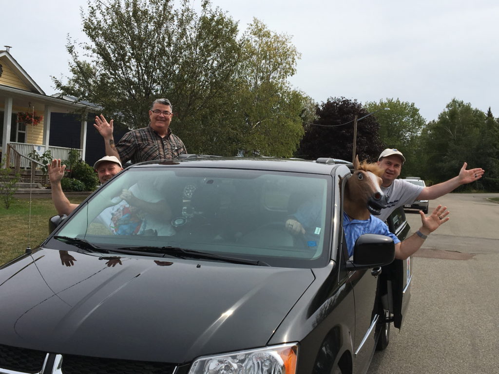
My son had his party, blew out his candles, had his cake, and as happy as I was that he was turning 10 years old, I was more excited about getting on the road but tried my hardest to hold it in. But when he unwrapped his gifts, and the celebration was over, I knew I was ready to go. A quick text message to Ken and within a few minutes, the van pulled up in front of the house.
Since our logo had all four of us leaning out of a car, my wife got us to pose in the van in the same way. That shot was the first real image we posted to Instagram for our website. From that point forward, we were officially on the road. Well, almost.
The van was rented from Enterprise Rent a Car on West Main St in Moncton. Ken had picked the vehicle up before we could leave on our excursion, but we all had to stop at the rental office for them to make copies of our licenses. We didn’t think it would take that long, but sure enough, after wanting to get on the road so badly, we stood there for what felt like an eternity waiting for the agent to finish with another customer before they took our licenses. It then felt like forever waiting for them to come back so we could leave. But eventually we did finish our visit there, got back in the van, turned right on to Main St, and the trip began. A year in the making, we were finally putting rubber to road.